Article
St Albert
St Albert, Alta, incorporated as a city in 1977, population 61 466 (2011c), 57 764 (2006c). The City of St Albert is located along the northwestern city boundary of EDMONTON.
Signing up enhances your TCE experience with the ability to save items to your personal reading list, and access the interactive map.
Create AccountArticle
St Albert, Alta, incorporated as a city in 1977, population 61 466 (2011c), 57 764 (2006c). The City of St Albert is located along the northwestern city boundary of EDMONTON.
"https://d3d0lqu00lnqvz.cloudfront.net/media/media/d0a2938b-4548-4d63-8063-2fa2e8a1b54e.jpg" // resources/views/front/categories/view.blade.phphttps://d3d0lqu00lnqvz.cloudfront.net/media/media/d0a2938b-4548-4d63-8063-2fa2e8a1b54e.jpg

Article
St. Catharines, ON, incorporated as a city in 1876, population 136,803 (2021 census), 133,113 (2016 census). The City of St. Catharines is the principal city of the Niagara Region. It lies south of Toronto across Lake Ontario (111 km by the Queen Elizabeth Way), 19 km inland from the international boundary with the United States, along the Niagara River. The city is named after Catharine Hamilton, wife of Robert Hamilton, an influential merchant of Queenston and a landowner with mills on Twelve Mile Creek; the growing community, then known as The Twelve or Shipman's Corners, was renamed in her honour after her death in 1796. After 1876, as the urban area of St. Catharines expanded, it was permitted to annex parts of the surrounding Grantham Township, culminating in 1961 in the complete amalgamation of the township as well as the adjacent towns of Merritton and Port Dalhousie. In 1970, the rural township of Louth to the west was split between St. Catharines and the new town of Lincoln.
"https://d3d0lqu00lnqvz.cloudfront.net/media/media/0b59b887-a76a-4eea-9406-10f64badd85e.jpg" // resources/views/front/categories/view.blade.phphttps://d3d0lqu00lnqvz.cloudfront.net/media/media/0b59b887-a76a-4eea-9406-10f64badd85e.jpg

Article
St. John's, NL, incorporated as a city in 1921, population 110,525 (2021 census), 108,860 (2016 census). The capital and largest city of Newfoundland and Labrador, the city of St. John's is located on the eastern side of the Avalon Peninsula of southeast Newfoundland. Its landlocked harbour is approached through a long, narrow channel and is protected by the high hills on which the city is built. The origin of the name St. John's is not known, but its use appears on a Portuguese map by Pedro Reinel (1516–20) as "Rio de San Johem" and later, in a 1527 letter by the English seaman John Rut, as the "Haven of St. John's." According to popular folklore, however, the city takes its name from the feast of Saint John the Baptist and the arrival of Italian explorer Giovanni Caboto (John Cabot) on the shores of Newfoundland on 24 June 1497.
"https://d3d0lqu00lnqvz.cloudfront.net/media/media/fa98a7ea-65f5-47f6-9d63-252242142821.jpg" // resources/views/front/categories/view.blade.phphttps://d3d0lqu00lnqvz.cloudfront.net/media/media/fa98a7ea-65f5-47f6-9d63-252242142821.jpg

Article
St Thomas, Ont, incorporated as a city in 1881, seat of Elgin County, population 37 905 (2011c), 36 110 (2006c). The City of St Thomas is located in southwestern Ontario, 29 km south of London. In 1803 Thomas TALBOT began to place settlers on a large tract of land he owned N of Lake Erie.
"https://www.thecanadianencyclopedia.ca/images/tce_placeholder.jpg?v=e9dca980c9bdb3aa11e832e7ea94f5d9" // resources/views/front/categories/view.blade.phphttps://www.thecanadianencyclopedia.ca/images/tce_placeholder.jpg?v=e9dca980c9bdb3aa11e832e7ea94f5d9

Article
Steinbach, Manitoba, incorporated as a city in 1997, population 13 524 (2011c), 11 066 (2006c). The City of Steinbach is located 48 km southeast of WINNIPEG.
"https://d3d0lqu00lnqvz.cloudfront.net/media/media/6ed4bd95-16b4-43e8-8409-f8c8d9d56b8f.jpg" // resources/views/front/categories/view.blade.phphttps://d3d0lqu00lnqvz.cloudfront.net/media/media/6ed4bd95-16b4-43e8-8409-f8c8d9d56b8f.jpg

Article
Urban growth was slow until the railway-building boom of the 1850s. Stratford businessmen lobbied for the forming in 1853 of the County of Perth, with Stratford as the county seat, and the county at once voted bonuses to railway companies.
"https://d3d0lqu00lnqvz.cloudfront.net/media/media/664057ff-dd11-4f37-abff-a514d6fb143e.jpg" // resources/views/front/categories/view.blade.phphttps://d3d0lqu00lnqvz.cloudfront.net/media/media/664057ff-dd11-4f37-abff-a514d6fb143e.jpg

Article
Greater Sudbury, Ontario, incorporated as a city in 2001, population 166,004 (2021 census), 161,531 (2016 census). The judicial seat for the District of Sudbury, the City of Greater Sudbury is located on the western shore of Ramsey Lake, about 60 km north of Georgian Bay. When incorporated in 2001, it replaced the former Regional Municipality of Sudbury (1973–2000) and City of Sudbury (1930–2000). The city owes much of its development to the mining industry, in particular, the mining of nickel. The largest urban area in northeastern Ontario, Greater Sudbury, now offers a concentration of business, cultural and educational services and is recognized for the impressive regreening program that it has been carrying out since the 1970s.
"https://d3d0lqu00lnqvz.cloudfront.net/media/media/4508a162-1478-4016-a9fe-a629711736ab.jpg" // resources/views/front/categories/view.blade.phphttps://d3d0lqu00lnqvz.cloudfront.net/media/media/4508a162-1478-4016-a9fe-a629711736ab.jpg

Article
Surrey, British Columbia, incorporated as a city in 1993, population 568,322 (2021 census), 517,887 (2016 census). The city of Surrey is the second-largest municipality by population in British Columbia, after Vancouver. Part of Metro Vancouver, it is bounded by the Fraser River on the north and Washington state on the south. The municipalities of Langley and Delta lie to the east and west.
"https://www.thecanadianencyclopedia.ca/images/tce_placeholder.jpg?v=e9dca980c9bdb3aa11e832e7ea94f5d9" // resources/views/front/categories/view.blade.phphttps://www.thecanadianencyclopedia.ca/images/tce_placeholder.jpg?v=e9dca980c9bdb3aa11e832e7ea94f5d9
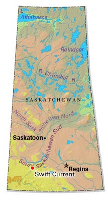
Article
Swift Current began to adopt the persona of a community in 1883 with the appearance of a dam, water tank, freight sheds, roadhouse and dining room. For many years it has served a large ranching, mixed-farming and grain-farming area.
"https://d3d0lqu00lnqvz.cloudfront.net/media/media/5ff60670-5d29-40af-bc8c-2490e8c26d9d.jpg" // resources/views/front/categories/view.blade.phphttps://d3d0lqu00lnqvz.cloudfront.net/media/media/5ff60670-5d29-40af-bc8c-2490e8c26d9d.jpg
Article
Terrace, BC, incorporated as a city in 1987, population 11 486 (2011c), 11 320 (2006c).
"https://www.thecanadianencyclopedia.ca/images/tce_placeholder.jpg?v=e9dca980c9bdb3aa11e832e7ea94f5d9" // resources/views/front/categories/view.blade.phphttps://www.thecanadianencyclopedia.ca/images/tce_placeholder.jpg?v=e9dca980c9bdb3aa11e832e7ea94f5d9
Article
Vieux Terrebonne is a veritable heritage storehouse. The historic buildings and landmarks of the old village centre recall the role played by the NORTH WEST COMPANY in the history of Terrebonne.
"https://www.thecanadianencyclopedia.ca/images/tce_placeholder.jpg?v=e9dca980c9bdb3aa11e832e7ea94f5d9" // resources/views/front/categories/view.blade.phphttps://www.thecanadianencyclopedia.ca/images/tce_placeholder.jpg?v=e9dca980c9bdb3aa11e832e7ea94f5d9
Article
Thetford Mines, Quebec, incorporated as a city in 1905, population 26,072 (2021 census), population 25,403 (2016 census). The city of Thetford Mines is located on the Bécancour River in the Appalachian Mountains, 107 km south of Quebec City. It was named after the town of Thetford in Norfolk, England. During the 20th century, it was one of the world’s largest asbestos mining and production centres.
"https://d3d0lqu00lnqvz.cloudfront.net/media/new_article_images/ThetfordMines/ThetfordMines.jpg" // resources/views/front/categories/view.blade.phphttps://d3d0lqu00lnqvz.cloudfront.net/media/new_article_images/ThetfordMines/ThetfordMines.jpg

Article
Thompson, Manitoba, incorporated as a city in 1970, population 12 829 (2011c), 13 446 (2006c). The City of Thompson is located on the south side of the Burntwood River, 740 km north of Winnipeg.
"https://d3d0lqu00lnqvz.cloudfront.net/media/media/47481ba8-856b-414e-a45d-175e7b331f81.jpg" // resources/views/front/categories/view.blade.phphttps://d3d0lqu00lnqvz.cloudfront.net/media/media/47481ba8-856b-414e-a45d-175e7b331f81.jpg

Article
Thorold, Ont, incorporated as a city in 1975, population 17 931 (2011c), 18 224 (2006c). The City of Thorold is situated on the NIAGARA PENINSULA. Though physically linked to ST CATHARINES, its large neighbour directly to the
"https://www.thecanadianencyclopedia.ca/images/tce_placeholder.jpg?v=e9dca980c9bdb3aa11e832e7ea94f5d9" // resources/views/front/categories/view.blade.phphttps://www.thecanadianencyclopedia.ca/images/tce_placeholder.jpg?v=e9dca980c9bdb3aa11e832e7ea94f5d9
Article
Thunder Bay, ON, incorporated as a city in 1970, population 107,909 (2016 census), 108,359 (2011 census). The City of Thunder Bay was created by the amalgamation of the cities of Fort William and Port Arthur and the townships of Neebing and McIntyre. It is located in northwestern Ontario on the west shore of the Lake Superior bay of the same name. Thunder Bay is situated on the traditional territory of the Anishinaabeg, and the land is covered by the Robinson-Superior Treaty. The Port of Thunder Bay is a western stop along the Great Lakes-St Lawrence Seaway. The region’s geography is dominated by the rocks, lakes and forests of the Canadian Shield. Surrounding communities depend on tourism or resource extraction, and look to Thunder Bay for a wide variety of services.
"https://d3d0lqu00lnqvz.cloudfront.net/media/new_article_images/ThunderBay/12171019064_8ca50f0bb8_z.jpg" // resources/views/front/categories/view.blade.phphttps://d3d0lqu00lnqvz.cloudfront.net/media/new_article_images/ThunderBay/12171019064_8ca50f0bb8_z.jpg
