Article
Timmins
Timmins, Ontario, incorporated as a city in 1973, population 41,145 (2021 census), 41,788 (2016 census). The city of Timmins is located 290 km northwest of Greater Sudbury.
Signing up enhances your TCE experience with the ability to save items to your personal reading list, and access the interactive map.
Create AccountArticle
Timmins, Ontario, incorporated as a city in 1973, population 41,145 (2021 census), 41,788 (2016 census). The city of Timmins is located 290 km northwest of Greater Sudbury.
"https://d3d0lqu00lnqvz.cloudfront.net/media/media/77a2b646-1dd7-44c2-8094-136b666d627e.jpg" // resources/views/front/categories/view.blade.phphttps://d3d0lqu00lnqvz.cloudfront.net/media/media/77a2b646-1dd7-44c2-8094-136b666d627e.jpg

Article
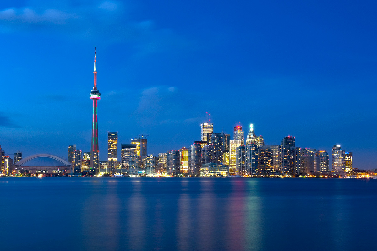
Toronto, Ontario, incorporated as a city in 1834, population 2,794,356 (2021 census), 2,731,571 (2016 census). Toronto is Ontario’s capital city, Canada’s largest municipality and the fourth largest city in North America (see also Largest Cities in Canada by Population). It is made up of the former cities of Toronto, North York, Scarborough, York and Etobicoke, and the former borough of East York. The city is home to a large immigrant population, and is a national and international hub for finance, communications and cultural life.
"https://d3d0lqu00lnqvz.cloudfront.net/media/media/Toronto_Skyline_2011_CityofTOFlickrCC.jpg" // resources/views/front/categories/view.blade.phphttps://d3d0lqu00lnqvz.cloudfront.net/media/media/Toronto_Skyline_2011_CityofTOFlickrCC.jpg
Article
Trois-Rivières, Quebec, incorporated as a city in 1857, population 139,163 (2021 census), 134,413 (2016 census). The city is located at the mouth of the Saint-Maurice River, on the north shore of the St. Lawrence, midway between Quebec City and Montreal and is the regional capital of Quebec's Mauricie region. Its name derives from the 3-armed delta formed by the river's islands at its mouth.
"https://d3d0lqu00lnqvz.cloudfront.net/media/media/f64e6118-f564-4f2e-aee3-8d7194dda785.jpg" // resources/views/front/categories/view.blade.phphttps://d3d0lqu00lnqvz.cloudfront.net/media/media/f64e6118-f564-4f2e-aee3-8d7194dda785.jpg

Article
Uranium City, Saskatchewan, northern settlement, population 91 (2021 census), 73 (2016 census). Uranium City is located about 50 km south of the provincial boundary with the Northwest Territories and 75 km east of the Saskatchewan-Alberta border.
"https://d3d0lqu00lnqvz.cloudfront.net/media/new_article_images/UraniumCity/Uranium_City.jpg" // resources/views/front/categories/view.blade.phphttps://d3d0lqu00lnqvz.cloudfront.net/media/new_article_images/UraniumCity/Uranium_City.jpg

Article
The name Bélair stems back to the original seigneury granted to Guillaume Bonhomme in 1682 by Governor Joseph-Antoine Le Febvre de LA BARRE and Intendant Jacques de MEULLES. In a 1733 census the seigneury was designated as "the fief commonly referred to as Bélair or Bonhomme.
"https://www.thecanadianencyclopedia.ca/images/tce_placeholder.jpg?v=e9dca980c9bdb3aa11e832e7ea94f5d9" // resources/views/front/categories/view.blade.phphttps://www.thecanadianencyclopedia.ca/images/tce_placeholder.jpg?v=e9dca980c9bdb3aa11e832e7ea94f5d9

Article
Vancouver, British Columbia, incorporated as a city in 1886, population 662,248 (2021 census), 631,486 (2016 census). Vancouver is the largest city in British Columbia and the eighth largest in Canada (see also Largest Cities in Canada by Population). The City of Vancouver lies on a peninsula in the southwest corner of the province's mainland. Two surrounding waterways — Burrard Inlet and the Strait of Georgia — provide a sheltered deep-sea port and convenient access to the Pacific Ocean, while the Fraser River offers an easy route to the rich agricultural lands of the Fraser River Lowland and the interior. Railways and highways give easy access to the interior.
"https://d3d0lqu00lnqvz.cloudfront.net/media/media/f2be1fdb-d1a8-4882-ba4b-0616d8cbfdd6.jpg" // resources/views/front/categories/view.blade.phphttps://d3d0lqu00lnqvz.cloudfront.net/media/media/f2be1fdb-d1a8-4882-ba4b-0616d8cbfdd6.jpg

Article
Vanier, Qué, City, pop 11 054 (2001c), 11 174 (1996c), 10 833(1991c), area 4.59 km2, inc 1916, was originally named Québec-Ouest until 1966, when it was changed to Vanier in honour of Governor-General Georges-Philéas VANIER.
"https://www.thecanadianencyclopedia.ca/images/tce_placeholder.jpg?v=e9dca980c9bdb3aa11e832e7ea94f5d9" // resources/views/front/categories/view.blade.phphttps://www.thecanadianencyclopedia.ca/images/tce_placeholder.jpg?v=e9dca980c9bdb3aa11e832e7ea94f5d9
Article
Canada's largest concentration of researchers in the field of ENERGY is concentrated in Varennes.
"https://d3d0lqu00lnqvz.cloudfront.net/media/media/1a704adb-dfed-40f4-bbe4-bb40c5cf3113.jpg" // resources/views/front/categories/view.blade.phphttps://d3d0lqu00lnqvz.cloudfront.net/media/media/1a704adb-dfed-40f4-bbe4-bb40c5cf3113.jpg

Article
The area was granted to Philippe de Rigaud de VAUDREUIL in 1703. However, it was his successor, Michel Chartier de Lotbinière, who fostered the settlement and development of the seigneury that he had bought from the Vaudreuil family in 1763. The FUR TRADE and agriculture supported the local economy.
"https://www.thecanadianencyclopedia.ca/images/tce_placeholder.jpg?v=e9dca980c9bdb3aa11e832e7ea94f5d9" // resources/views/front/categories/view.blade.phphttps://www.thecanadianencyclopedia.ca/images/tce_placeholder.jpg?v=e9dca980c9bdb3aa11e832e7ea94f5d9
Article
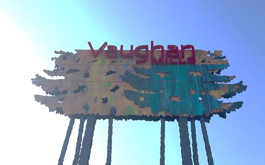
Vaughan, ON, incorporated as a city in 1991, population 323,103 (2021 census), 306,233 (2016 census). The City of Vaughan — which includes the five constituent communities of Maple, Kleinburg, Concord, Woodbridge and part of Thornhill — is located in the York regional municipality, next to the northwest boundary of metropolitan Toronto. Traditionally an agricultural and milling community, Vaughan’s economy diversified over the latter half of the 20th century as immigration increased and the township developed into a city. Today, Vaughan is a multicultural community with a growing metropolitan core.
"https://d3d0lqu00lnqvz.cloudfront.net/media/media/c51ebfa2-7e27-4826-aad3-bcb5814f2ad4.jpg" // resources/views/front/categories/view.blade.phphttps://d3d0lqu00lnqvz.cloudfront.net/media/media/c51ebfa2-7e27-4826-aad3-bcb5814f2ad4.jpg
Article
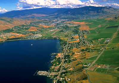
Vernon, British Columbia, incorporated as a city in 1892, population 40,116 (2016 census), 38,150 (2011 census). The City of Vernon is located in the North Okanagan Valley, nestled between Okanagan, Kalamalka and Swan lakes.
"https://d3d0lqu00lnqvz.cloudfront.net/media/media/9442225e-ac4a-4c14-83f0-31050d516a0b.jpg" // resources/views/front/categories/view.blade.phphttps://d3d0lqu00lnqvz.cloudfront.net/media/media/9442225e-ac4a-4c14-83f0-31050d516a0b.jpg
Article
Victoria, BC, incorporated as a city in 1862, population 91,867 (2021 census), 85,792 (2016 census). The capital of British Columbia, the City of Victoria is situated on the southern tip of Vancouver Island, about 100 km south of Vancouver. Occupying a peninsular site, Victoria is bordered by the Juan de Fuca and Haro straits. In addition, the Olympic Mountains lie to the south, the San Juan Islands to the east, and the fjord-like Saanich Inlet and richly forested Malahat Ridge and Sooke Hills to the west. Greater Victoria lies within the Capital Regional District (CRD), a federation comprising the following incorporated areas: the cities of Victoria, Colwood and Langford; the towns of Sidney and View Royal; and the municipalities of Saanich, Oak Bay, Esquimalt, Central Saanich, North Saanich, Sooke, Metchosin and Highlands. The CRD also includes the electoral areas of Juan de Fuca, the Southern Gulf Islands and Saltspring Island.
"https://d3d0lqu00lnqvz.cloudfront.net/media/media/f9eb6563-f419-4725-ba7c-e2de39a3daa1.jpg" // resources/views/front/categories/view.blade.phphttps://d3d0lqu00lnqvz.cloudfront.net/media/media/f9eb6563-f419-4725-ba7c-e2de39a3daa1.jpg

Article
Originally called Demersville for a local businessman, its name was changed in 1861 to honour Queen VICTORIA. In the early days the town was only a small train station on the GRAND TRUNK RAILWAY line between Québec City and Richmond, Qué.
"https://www.thecanadianencyclopedia.ca/images/tce_placeholder.jpg?v=e9dca980c9bdb3aa11e832e7ea94f5d9" // resources/views/front/categories/view.blade.phphttps://www.thecanadianencyclopedia.ca/images/tce_placeholder.jpg?v=e9dca980c9bdb3aa11e832e7ea94f5d9
Article
The area was first settled by MENNONITES led by the Erb family from Pennsylvania in 1806 on what was known as the German Company Tract. In 1816 the area was elevated to township status and named Waterloo after Wellington's famous victory over Napoleon in 1815.
"https://d3d0lqu00lnqvz.cloudfront.net/media/media/26432c79-930e-413e-bf55-568f0fb6211e.jpg" // resources/views/front/categories/view.blade.phphttps://d3d0lqu00lnqvz.cloudfront.net/media/media/26432c79-930e-413e-bf55-568f0fb6211e.jpg

Article
Welland, Ontario, incorporated as a city in 1917, population 52,293 (2016 census), 50,631 (2011 census). The city of Welland is located on the Niagara Peninsula, 24 km south of St. Catharines. It is named after the Welland River.
"https://www.thecanadianencyclopedia.ca/images/tce_placeholder.jpg?v=e9dca980c9bdb3aa11e832e7ea94f5d9" // resources/views/front/categories/view.blade.phphttps://www.thecanadianencyclopedia.ca/images/tce_placeholder.jpg?v=e9dca980c9bdb3aa11e832e7ea94f5d9