Article
Humber River (Newfoundland)
The Humber River, 153 km long, drainage basin 7680 km2, is the principal river of western Newfoundland.
Signing up enhances your TCE experience with the ability to save items to your personal reading list, and access the interactive map.
Create AccountArticle
The Humber River, 153 km long, drainage basin 7680 km2, is the principal river of western Newfoundland.
"https://www.thecanadianencyclopedia.ca/images/tce_placeholder.jpg?v=e9dca980c9bdb3aa11e832e7ea94f5d9" // resources/views/front/categories/view.blade.phphttps://www.thecanadianencyclopedia.ca/images/tce_placeholder.jpg?v=e9dca980c9bdb3aa11e832e7ea94f5d9

Article
Encompassing 908 km2 in total, the Humber River watershed is the largest in the Toronto region. The 126-kilometre long Humber River has its headwaters in the ancient rock of the NIAGARA ESCARPMENT and the glacial hills of the Oak Ridges Moraine.
"https://www.thecanadianencyclopedia.ca/images/tce_placeholder.jpg?v=e9dca980c9bdb3aa11e832e7ea94f5d9" // resources/views/front/categories/view.blade.phphttps://www.thecanadianencyclopedia.ca/images/tce_placeholder.jpg?v=e9dca980c9bdb3aa11e832e7ea94f5d9
List
The names of many rivers and lakes in Canada have Indigenous origins. These bodies of water are named for Indigenous people, places, and aspects of Indigenous culture. Some of these lakes and rivers still bear the original name given to them by Indigenous people. Others have been renamed using an Indigenous word as a means of recognizing Indigenous history and working toward reconciliation. This list article explores the Indigenous names of five rivers and five lakes in Canada. (See also Longest Rivers in Canada and Largest Lakes in Canada.)
"https://d3d0lqu00lnqvz.cloudfront.net/media/media/19ec5b64-165b-4f1c-b539-c89700680c09.jpg" // resources/views/front/categories/view.blade.phphttps://d3d0lqu00lnqvz.cloudfront.net/media/media/19ec5b64-165b-4f1c-b539-c89700680c09.jpg

Article
Kazan River, 850 km long, rises near Kasba Lake in southern Nunavut near the Saskatchewan border. Flowing north it follows an irregular course through several lakes, draining a large part of the Barren Lands.
"https://www.thecanadianencyclopedia.ca/images/tce_placeholder.jpg?v=e9dca980c9bdb3aa11e832e7ea94f5d9" // resources/views/front/categories/view.blade.phphttps://www.thecanadianencyclopedia.ca/images/tce_placeholder.jpg?v=e9dca980c9bdb3aa11e832e7ea94f5d9
Article
The Kicking Horse River begins as glacial meltwater streams flowing down the west slope of the Rocky Mountains.
"https://www.thecanadianencyclopedia.ca/images/tce_placeholder.jpg?v=e9dca980c9bdb3aa11e832e7ea94f5d9" // resources/views/front/categories/view.blade.phphttps://www.thecanadianencyclopedia.ca/images/tce_placeholder.jpg?v=e9dca980c9bdb3aa11e832e7ea94f5d9
Article
La Grande Rivière, 893 km long, rises in the rugged forest highlands of central Québec and drains west into James Bay.
"https://d3d0lqu00lnqvz.cloudfront.net/media/media/33649494-8426-4ec2-8001-9f2613ea3d08.jpg" // resources/views/front/categories/view.blade.phphttps://d3d0lqu00lnqvz.cloudfront.net/media/media/33649494-8426-4ec2-8001-9f2613ea3d08.jpg

Article
The Liard River is 1,115 km long and is a major tributary to the Mackenzie River.
"https://d3d0lqu00lnqvz.cloudfront.net/media/media/d8c9eefb-7ec2-49a9-afc5-1b3766fa968f.jpg" // resources/views/front/categories/view.blade.phphttps://d3d0lqu00lnqvz.cloudfront.net/media/media/d8c9eefb-7ec2-49a9-afc5-1b3766fa968f.jpg

Article
The Mackenzie River’s main stem is 1,738 km long, making it one of the longest rivers in Canada. The Mackenzie River system, which includes tributaries such as the Liard River, is 4,241 km. The Mackenzie River runs northwest through the Northwest Territories, from Great Slave Lake to the Beaufort Sea. Its total drainage basin — 1.8 million km2 — is the largest of any river in Canada and its mean discharge of 9,700 m3/s is second only to that of the St. Lawrence. The river's peak discharge occurs in June, but its flow is generally uniform because of the flat topography east of the river and the many large lakes in the system. The break-up of ice begins at the Liard River in late April, early May. The river is free of ice by early June and stays open until November.
"https://d3d0lqu00lnqvz.cloudfront.net/media/media/b24a9945-1be2-4260-8b49-797cdcb3558e.jpg" // resources/views/front/categories/view.blade.phphttps://d3d0lqu00lnqvz.cloudfront.net/media/media/b24a9945-1be2-4260-8b49-797cdcb3558e.jpg

Article
From its 4 headwater lakes (called Four Ponds - lakes are called "ponds" in Newfoundland and Labrador) in the Long Range Mountains on Newfoundland and Labrador's Great Northern Peninsula, the Main River drops quickly over boulder-strewn rapids.
"https://www.thecanadianencyclopedia.ca/images/tce_placeholder.jpg?v=e9dca980c9bdb3aa11e832e7ea94f5d9" // resources/views/front/categories/view.blade.phphttps://www.thecanadianencyclopedia.ca/images/tce_placeholder.jpg?v=e9dca980c9bdb3aa11e832e7ea94f5d9
Article
The Margaree-Lake Ainslie system is the largest river system on Cape Breton Island, and one of the largest in Nova Scotia, with a total length of 120 km and a watershed of 1165 km2.
"https://www.thecanadianencyclopedia.ca/images/tce_placeholder.jpg?v=e9dca980c9bdb3aa11e832e7ea94f5d9" // resources/views/front/categories/view.blade.phphttps://www.thecanadianencyclopedia.ca/images/tce_placeholder.jpg?v=e9dca980c9bdb3aa11e832e7ea94f5d9
Article
The Mattawa River rises in Trout Lake in north-central Ontario, 198.5 m above sea level and drops to 50 m over around 65 km distance to the Ottawa River. Its watershed encompasses 1170 km2 of the Canadian Shield.
"https://www.thecanadianencyclopedia.ca/images/tce_placeholder.jpg?v=e9dca980c9bdb3aa11e832e7ea94f5d9" // resources/views/front/categories/view.blade.phphttps://www.thecanadianencyclopedia.ca/images/tce_placeholder.jpg?v=e9dca980c9bdb3aa11e832e7ea94f5d9
Article
WRITING-ON-STONE PROVINCIAL PARK and a natural area in Alberta protect parts of the river's remarkable landscapes. The American explorers Meriwether Lewis and William Clark gave the Milk River its name (in 1805) because its colour reminded them of a cup of tea mixed with milk.
"https://d3d0lqu00lnqvz.cloudfront.net/media/media/ae2dfa9d-3fd2-48ea-b69e-74d80a659e8b.jpg" // resources/views/front/categories/view.blade.phphttps://d3d0lqu00lnqvz.cloudfront.net/media/media/ae2dfa9d-3fd2-48ea-b69e-74d80a659e8b.jpg

Article
The Miramichi River is 217 km long from its source in Juniper, in central New Brunswick, to the Gulf of St. Lawrence.
"https://d3d0lqu00lnqvz.cloudfront.net/media/media/169334dd-4829-4936-a09b-b91e809c65ef.jpg" // resources/views/front/categories/view.blade.phphttps://d3d0lqu00lnqvz.cloudfront.net/media/media/169334dd-4829-4936-a09b-b91e809c65ef.jpg

Article
The Moose River is 547 km long from the head of its tributary, the Mattagami River. It is formed by the confluence of the Mattagami and the Missinaibi rivers, and flows northeast 104 km to discharge into the bottom of James Bay in northern Ontario.
"https://www.thecanadianencyclopedia.ca/images/tce_placeholder.jpg?v=e9dca980c9bdb3aa11e832e7ea94f5d9" // resources/views/front/categories/view.blade.phphttps://www.thecanadianencyclopedia.ca/images/tce_placeholder.jpg?v=e9dca980c9bdb3aa11e832e7ea94f5d9
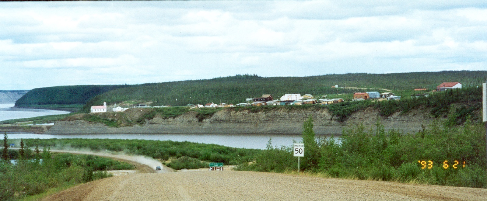
Article
Nagwichoonjik, meaning "river flowing through a big country," is the Gwich'in name for the Mackenzie River, the longest river in Canada and the 9th longest river in the world. The river flows through the heart of the traditional homeland of the Gwichya Gwich'in, who now largely reside in Tsiigehtchic (formerly Arctic Red River), a small community of 200 people at the confluence of the Arctic Red and Mackenzie rivers, in the northern part of the Northwest Territories. ( See also Indigenous Territory).
"https://d3d0lqu00lnqvz.cloudfront.net/media/new_article_images/Tsiigehtchic/TsiigehtchicBothRivers.jpg" // resources/views/front/categories/view.blade.phphttps://d3d0lqu00lnqvz.cloudfront.net/media/new_article_images/Tsiigehtchic/TsiigehtchicBothRivers.jpg