Article
Prince Edward Island National Park
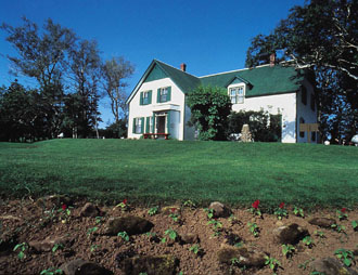
Prince Edward Island National Park (est 1937, 21.5 km2) is a narrow strip of coastline stretching over 40 km along the north shore of PEI.
Signing up enhances your TCE experience with the ability to save items to your personal reading list, and access the interactive map.
Create AccountArticle
Prince Edward Island National Park (est 1937, 21.5 km2) is a narrow strip of coastline stretching over 40 km along the north shore of PEI.
"https://d3d0lqu00lnqvz.cloudfront.net/media/media/43c98966-afd6-46ad-88a3-937937a88fff.jpg" // resources/views/front/categories/view.blade.phphttps://d3d0lqu00lnqvz.cloudfront.net/media/media/43c98966-afd6-46ad-88a3-937937a88fff.jpg
Article
Pukaskwa National Park (designated 1978, 1877.8 km2) is bracketed on the west by the coastline of Lake Superior, an impressive stretch of massive headlands and beaches of golden sand or water-worn cobble. The name is of native origin but its meaning is unclear.
"https://d3d0lqu00lnqvz.cloudfront.net/media/media/8fa1ba40-04c8-4e20-b684-d478d83147ff.jpg" // resources/views/front/categories/view.blade.phphttps://d3d0lqu00lnqvz.cloudfront.net/media/media/8fa1ba40-04c8-4e20-b684-d478d83147ff.jpg

Article
Qausuittuq National Park encompasses 11,000 km2 on northern Bathurst Island and smaller surrounding islands in Nunavut. It also includes the waters of May Inlet and Young Inlet. Pronounced Kow-soo-ee-took, the name of this park translates to “the place where the sun doesn’t rise” in Inuktitut. It is bordered to the south by Polar Bear Pass National Wildlife Area, and together these two zones protect a large, ecologically intact area in the Canadian Arctic Archipelago. Qausuittuq was established on 1 September 2015 as Canada’s 45th national park. It represents the Western High Arctic Natural Region, the 38th natural region of the 39 that constitute Canada’s national parks system.
"https://d3d0lqu00lnqvz.cloudfront.net/media/media/b24f1a0a-425c-40af-87b6-16d3164c5e60.jpg" // resources/views/front/categories/view.blade.phphttps://d3d0lqu00lnqvz.cloudfront.net/media/media/b24f1a0a-425c-40af-87b6-16d3164c5e60.jpg

Article
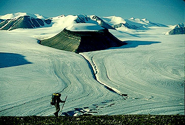
Quttinirpaaq National Park (established 1988, 37 775 km2) is Canada's second-largest national park (after Wood Buffalo National Park).
"https://d3d0lqu00lnqvz.cloudfront.net/media/media/5176d9ce-bf5f-4fdf-9453-c0f71b3128e6.jpg" // resources/views/front/categories/view.blade.phphttps://d3d0lqu00lnqvz.cloudfront.net/media/media/5176d9ce-bf5f-4fdf-9453-c0f71b3128e6.jpg
Article
Natural History The park is a rolling landscape of mixed forests and grasslands dotted with lakes, streams and bogs, an "island" of green rising out of a sea of farmland.
"https://d3d0lqu00lnqvz.cloudfront.net/media/media/c9679ffa-5ed0-4a59-995b-e07de3516e05.jpg" // resources/views/front/categories/view.blade.phphttps://d3d0lqu00lnqvz.cloudfront.net/media/media/c9679ffa-5ed0-4a59-995b-e07de3516e05.jpg

Article
Located on northern Baffin Island in Canada's High Arctic, Sirmilik National Park (agreement signed 1999; 22 250 km2) is one of Canada's isolated and most spectacular national parks. Sirmilik is an Inuktitut word that means "place of glaciers."
"https://d3d0lqu00lnqvz.cloudfront.net/media/media/99e23c81-75f9-472e-8482-f10ddb1bb260.jpg" // resources/views/front/categories/view.blade.phphttps://d3d0lqu00lnqvz.cloudfront.net/media/media/99e23c81-75f9-472e-8482-f10ddb1bb260.jpg

Article
Most of the park islands are the summits of ancient hills of the Frontenac Axis, a strip of Precambrian granite connecting the Canadian Shield with the Adirondack Mountains in New York State.
"https://d3d0lqu00lnqvz.cloudfront.net/media/media/fad571a1-9624-4927-9403-e3b2560a4951.jpg" // resources/views/front/categories/view.blade.phphttps://d3d0lqu00lnqvz.cloudfront.net/media/media/fad571a1-9624-4927-9403-e3b2560a4951.jpg

Article
Terra Nova National Park (est 1957, 399.9 km2), Canada's most easterly national park, is located on Bonavista Bay, Nfld. Terra Nova is the Latin form of the name of the island, Newfoundland.
"https://d3d0lqu00lnqvz.cloudfront.net/media/media/47baa2cc-e48f-4b39-bfd5-4383b6cdfaa9.jpg" // resources/views/front/categories/view.blade.phphttps://d3d0lqu00lnqvz.cloudfront.net/media/media/47baa2cc-e48f-4b39-bfd5-4383b6cdfaa9.jpg

Article
Torngat Mountains National Park (established in 2008) encompasses 9700 km2 of Labrador north of Saglek Fiord. Torngat - in Inuktitut, Torngait - refers to one of the most powerful of Inuit spirits believed to dwell in these mountains.
"https://www.thecanadianencyclopedia.ca/images/tce_placeholder.jpg?v=e9dca980c9bdb3aa11e832e7ea94f5d9" // resources/views/front/categories/view.blade.phphttps://www.thecanadianencyclopedia.ca/images/tce_placeholder.jpg?v=e9dca980c9bdb3aa11e832e7ea94f5d9

Article
Tuktut Nogait National Park (established in 1998, 18 181 km2) was created through the efforts of the Inuit of Paulatuk, NWT.
"https://www.thecanadianencyclopedia.ca/images/tce_placeholder.jpg?v=e9dca980c9bdb3aa11e832e7ea94f5d9" // resources/views/front/categories/view.blade.phphttps://www.thecanadianencyclopedia.ca/images/tce_placeholder.jpg?v=e9dca980c9bdb3aa11e832e7ea94f5d9
Article
Ukkusiksalik National Park, Nunavut, size 20,885 km2, established in 2003, is located on the northwest side of Hudson Bay. It was first proposed as a National Park in 1978 because of the spectacular inland sea, Wager Bay, and the surrounding area. The name Ukkusiksalik in Inuktitut means "the place where soapstone to make pots and oil lamps is found."
"https://www.thecanadianencyclopedia.ca/images/tce_placeholder.jpg?v=e9dca980c9bdb3aa11e832e7ea94f5d9" // resources/views/front/categories/view.blade.phphttps://www.thecanadianencyclopedia.ca/images/tce_placeholder.jpg?v=e9dca980c9bdb3aa11e832e7ea94f5d9
Article
A portion of the Old Crow Plain (locally called the Old Crow Flats) was set aside, through the settlement of the Vuntut Gwitchin comprehensive land claim in 1993, for Vuntut National Park (established 1995, 4345 km2).
"https://d3d0lqu00lnqvz.cloudfront.net/media/media/0280eee2-9f7c-4cb4-a65b-a6e43d457819.jpg" // resources/views/front/categories/view.blade.phphttps://d3d0lqu00lnqvz.cloudfront.net/media/media/0280eee2-9f7c-4cb4-a65b-a6e43d457819.jpg

Article
Wapusk National Park (11 475.0 km2) became part of Canada's national parks system on 24 April 1996 when a federal-provincial agreement was signed providing for its establishment.
"https://d3d0lqu00lnqvz.cloudfront.net/media/media/2288f5ad-7780-4e6a-b579-e6f1614efd4e.jpg" // resources/views/front/categories/view.blade.phphttps://d3d0lqu00lnqvz.cloudfront.net/media/media/2288f5ad-7780-4e6a-b579-e6f1614efd4e.jpg

Article
Waterton Lakes National Park (established 1895, 505 km2) is situated in the southwestern corner of Alberta on the Canada-US border. In 1932, this park was united with Montana's Glacier National Park to create the world's first international peace park.
"https://d3d0lqu00lnqvz.cloudfront.net/media/media/22e13f0f-0ba3-4040-ab1d-3cb7c02c5f56.jpg" // resources/views/front/categories/view.blade.phphttps://d3d0lqu00lnqvz.cloudfront.net/media/media/22e13f0f-0ba3-4040-ab1d-3cb7c02c5f56.jpg

Article
Wood Buffalo National Park (established in 1922, 44 802 km2) was established to protect the last herd of wood bison. Canada's largest national park straddles the Alberta/NWT border. It was declared a World Heritage Site in 1983.
"https://d3d0lqu00lnqvz.cloudfront.net/media/media/dad4c55e-b36d-4cf2-8e66-7da2b6cc188a.jpg" // resources/views/front/categories/view.blade.phphttps://d3d0lqu00lnqvz.cloudfront.net/media/media/dad4c55e-b36d-4cf2-8e66-7da2b6cc188a.jpg
