Article
Street Railways
The low rolling resistance of steel wheels on steel rails, plus the simple guidance mechanism offered by flanges, has made rail-bound transport attractive for a variety of applications.

Enter your search term
Signing up enhances your TCE experience with the ability to save items to your personal reading list, and access the interactive map.
Create AccountArticle
The low rolling resistance of steel wheels on steel rails, plus the simple guidance mechanism offered by flanges, has made rail-bound transport attractive for a variety of applications.
"https://d3d0lqu00lnqvz.cloudfront.net/media/media/f1606166-71f5-45eb-b06b-09708d15f571.jpg" // resources/views/front/categories/view.blade.phphttps://d3d0lqu00lnqvz.cloudfront.net/media/media/f1606166-71f5-45eb-b06b-09708d15f571.jpg

Article
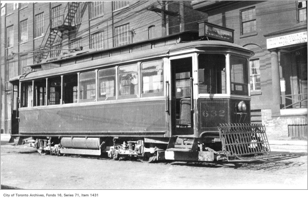
Streetcars began operation in Canada during the era of horse-powered local transportation, expanded rapidly with electrification, shrank with a public policy switch in favour of rubber-tired vehicles, and recently re-emerged as light rail transit.
"https://d3d0lqu00lnqvz.cloudfront.net/media/media/9abcd0e2-c095-4a4d-94ef-f9821b34c0e6.jpg" // resources/views/front/categories/view.blade.phphttps://d3d0lqu00lnqvz.cloudfront.net/media/media/9abcd0e2-c095-4a4d-94ef-f9821b34c0e6.jpg

Article
Studio de musique ancienne de Montréal. Ensemble of singers and instrumentalists dedicated to the performance of pre-1750 German, English, French, and Italian music 'in an informed and authentic spirit'.
"https://www.thecanadianencyclopedia.ca/images/tce_placeholder.jpg?v=e9dca980c9bdb3aa11e832e7ea94f5d9" // resources/views/front/categories/view.blade.phphttps://www.thecanadianencyclopedia.ca/images/tce_placeholder.jpg?v=e9dca980c9bdb3aa11e832e7ea94f5d9

Article
Sturgeon Falls, Ontario, population centre, population 6,939 (2021 census), 6,916 (2016 census). Sturgeon Falls is located 5 km up the Sturgeon River from Lake Nipissing. It was incorporated as a town in 1895. After a failed court challenge aimed at maintaining a separate identity (1997), Sturgeon Falls is now the administrative centre for the provincially-mandated town of West Nipissing (incorporated 1990).
"https://www.thecanadianencyclopedia.ca/images/tce_placeholder.jpg?v=e9dca980c9bdb3aa11e832e7ea94f5d9" // resources/views/front/categories/view.blade.phphttps://www.thecanadianencyclopedia.ca/images/tce_placeholder.jpg?v=e9dca980c9bdb3aa11e832e7ea94f5d9

Article
Subways and Light Rapid Transit Subways, sometimes referred to as heavy rail transit, are urban, electric, rapid-transit lines capable of carrying large numbers of people: between 20 000 and 40 000 passengers per hour in each direction.
"https://www.thecanadianencyclopedia.ca/images/tce_placeholder.jpg?v=e9dca980c9bdb3aa11e832e7ea94f5d9" // resources/views/front/categories/view.blade.phphttps://www.thecanadianencyclopedia.ca/images/tce_placeholder.jpg?v=e9dca980c9bdb3aa11e832e7ea94f5d9

Article
Greater Sudbury, Ontario, incorporated as a city in 2001, population 166,004 (2021 census), 161,531 (2016 census). The judicial seat for the District of Sudbury, the City of Greater Sudbury is located on the western shore of Ramsey Lake, about 60 km north of Georgian Bay. When incorporated in 2001, it replaced the former Regional Municipality of Sudbury (1973–2000) and City of Sudbury (1930–2000). The city owes much of its development to the mining industry, in particular, the mining of nickel. The largest urban area in northeastern Ontario, Greater Sudbury, now offers a concentration of business, cultural and educational services and is recognized for the impressive regreening program that it has been carrying out since the 1970s.
"https://d3d0lqu00lnqvz.cloudfront.net/media/media/4508a162-1478-4016-a9fe-a629711736ab.jpg" // resources/views/front/categories/view.blade.phphttps://d3d0lqu00lnqvz.cloudfront.net/media/media/4508a162-1478-4016-a9fe-a629711736ab.jpg

Article
Sudbury, Ont. Mining community in northern Ontario. Settled in 1883 and incorporated as city in 1930, Sudbury by 1986 had a population of 88,717 from a variety of national origins.
"https://www.thecanadianencyclopedia.ca/images/tce_placeholder.jpg?v=e9dca980c9bdb3aa11e832e7ea94f5d9" // resources/views/front/categories/view.blade.phphttps://www.thecanadianencyclopedia.ca/images/tce_placeholder.jpg?v=e9dca980c9bdb3aa11e832e7ea94f5d9

Article
Summerland, BC, incorporated as a district municipality in 1906, population 11 280 (2011c), 10 828 (2006c). The District of Summerland is located on the west bank of OKANAGAN LAKE in the southern interior of British Columbia between KELOWNA and PENTICTON.
"https://d3d0lqu00lnqvz.cloudfront.net/media/media/0244c898-89ec-490e-8fce-58f57b91df26.jpg" // resources/views/front/categories/view.blade.phphttps://d3d0lqu00lnqvz.cloudfront.net/media/media/0244c898-89ec-490e-8fce-58f57b91df26.jpg

Article
Beginning around 1910, the town experienced renewed prosperity as a fur-trading centre, stimulated by Sir Charles Dalton and Robert T. Oulton's successful breeding of silver foxes in captivity. In 1920 Summerside was established as the headquarters of the Canadian National Silver Fox Breeders' Assn.
"https://d3d0lqu00lnqvz.cloudfront.net/media/media/c92b22e5-2797-46d3-bd33-d318ecb6cc64.jpg" // resources/views/front/categories/view.blade.phphttps://d3d0lqu00lnqvz.cloudfront.net/media/media/c92b22e5-2797-46d3-bd33-d318ecb6cc64.jpg

"https://d3d0lqu00lnqvz.cloudfront.net/media/media/a75c407d-aa04-450d-9516-94bdc0f4f3f3.jpg" // resources/views/front/categories/view.blade.phphttps://d3d0lqu00lnqvz.cloudfront.net/media/media/a75c407d-aa04-450d-9516-94bdc0f4f3f3.jpg

Article
Surrey, British Columbia, incorporated as a city in 1993, population 568,322 (2021 census), 517,887 (2016 census). The city of Surrey is the second-largest municipality by population in British Columbia, after Vancouver. Part of Metro Vancouver, it is bounded by the Fraser River on the north and Washington state on the south. The municipalities of Langley and Delta lie to the east and west.
"https://www.thecanadianencyclopedia.ca/images/tce_placeholder.jpg?v=e9dca980c9bdb3aa11e832e7ea94f5d9" // resources/views/front/categories/view.blade.phphttps://www.thecanadianencyclopedia.ca/images/tce_placeholder.jpg?v=e9dca980c9bdb3aa11e832e7ea94f5d9

Article
Sussex, NB, incorporated as a town in 1904, population 4312 (2011c), 4241 (2006c). The Town of Sussex is located in south-central New Brunswick in a rich agricultural area, 73 km from SAINT JOHN on the Kennebecasis River.
"https://www.thecanadianencyclopedia.ca/images/tce_placeholder.jpg?v=e9dca980c9bdb3aa11e832e7ea94f5d9" // resources/views/front/categories/view.blade.phphttps://www.thecanadianencyclopedia.ca/images/tce_placeholder.jpg?v=e9dca980c9bdb3aa11e832e7ea94f5d9

Article
Sverdrup Islands, located in the High Arctic, comprise a large island, Axel Heiberg, and two smaller ones, Ellef Ringnes and Amund Ringnes. Their geological history began as an area of subsidence and sedimentation on a landmass margin.
"https://www.thecanadianencyclopedia.ca/images/tce_placeholder.jpg?v=e9dca980c9bdb3aa11e832e7ea94f5d9" // resources/views/front/categories/view.blade.phphttps://www.thecanadianencyclopedia.ca/images/tce_placeholder.jpg?v=e9dca980c9bdb3aa11e832e7ea94f5d9

Article
Swan Hills, Alta, incorporated as a town in 1967, population 1465 (2011c), 1645 (2006c). The Town of Swan Hills is located in the Swan Hills, 209 km northwest of Edmonton. The Swan Hills were named by the Cree for legendary giant swans whose thundering wings would fill the air.
"https://d3d0lqu00lnqvz.cloudfront.net/media/media/c832dba4-b8a8-4794-a903-4d960dbe55b2.jpg" // resources/views/front/categories/view.blade.phphttps://d3d0lqu00lnqvz.cloudfront.net/media/media/c832dba4-b8a8-4794-a903-4d960dbe55b2.jpg

Article
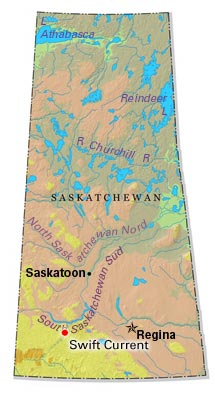
Swift Current began to adopt the persona of a community in 1883 with the appearance of a dam, water tank, freight sheds, roadhouse and dining room. For many years it has served a large ranching, mixed-farming and grain-farming area.
"https://d3d0lqu00lnqvz.cloudfront.net/media/media/5ff60670-5d29-40af-bc8c-2490e8c26d9d.jpg" // resources/views/front/categories/view.blade.phphttps://d3d0lqu00lnqvz.cloudfront.net/media/media/5ff60670-5d29-40af-bc8c-2490e8c26d9d.jpg
