Places | The Canadian Encyclopedia

Browse "Places"

Displaying 1426-1440 of 2279 results
  • Timelines

    Ontario

    Ontario is Canada's most populous and second-largest province. It stretches from Canada's southernmost point at Middle Island in Lake Erie in the south, to the Manitoba-Ontario border on Hudson Bay in the north, and from the banks of the St. Lawrence River in the east, to the Manitoba border in the west.

    "https://d3d0lqu00lnqvz.cloudfront.net/media/media/08da0fa3-1249-445f-9b67-c59bc9256242.JPG" // resources/views/front/categories/view.blade.php
    
    https://d3d0lqu00lnqvz.cloudfront.net/media/media/08da0fa3-1249-445f-9b67-c59bc9256242.JPG Ontario
  • Article

    Ontario Place

    Ontario Place is a 155-acre tourist attraction located on the Lake Ontario shoreline in Toronto. Operated by the Province of Ontario, the park opened on 22 May 1971. A highlight of the $29-million project was the Cinesphere, the world’s first permanent IMAX theatre. Aside from Atlantis (an event space), the marina and its music venues, the provincial government closed Ontario Place between 2012 and 2017 to save money. While many of the park’s attractions permanently closed during this period, others, such as the Cinesphere, reopened. The provincial government is working with various developers to further reimagine the space.

    "https://d3d0lqu00lnqvz.cloudfront.net/media/new_article_images/OntarioPlace/OntarioPlaceCinesphere80s.jpg" // resources/views/front/categories/view.blade.php
    
    https://d3d0lqu00lnqvz.cloudfront.net/media/new_article_images/OntarioPlace/OntarioPlaceCinesphere80s.jpg Ontario Place
  • Article

    Ontario Place Forum

    Ontario Place Forum. Outdoor amphitheatre, part of Ontario Place, a provincially-operated recreational park opened in 1971 on three man-made islands off the Toronto waterfront. The Forum is circular in design and set in a basin created by four hills.

    "https://www.thecanadianencyclopedia.ca/images/tce_placeholder.jpg?v=e9dca980c9bdb3aa11e832e7ea94f5d9" // resources/views/front/categories/view.blade.php
    
    https://www.thecanadianencyclopedia.ca/images/tce_placeholder.jpg?v=e9dca980c9bdb3aa11e832e7ea94f5d9 Ontario Place Forum
  • Article

    Ontario's Greenbelt

    Ontario’s Greenbelt, also known as the Greater Golden Horseshoe Greenbelt, is about 800,000 hectares of permanently protected green space and farmland in Ontario. It is one of many prominent greenbelts worldwide, including the British Columbia Agricultural Land Reserve in Canada and greenbelts in Copenhagen, Brazil, London, England and elsewhere. The Greenbelt forms a “belt” around the Greater Golden Horseshoe, Canada’s most densely populated area. The region includes municipalities such as Toronto, Oakville, Pickering, Hamilton, and Mississauga and stretches from Rice Lake in the east to the Niagara River in the west. The Greenbelt was created in 2005 to protect high-quality farmland and environmentally sensitive features like forests, lakes and sensitive species from urban sprawl and development.

    "https://d3d0lqu00lnqvz.cloudfront.net/greenbelt/oak-ridges-moraine.jpg" // resources/views/front/categories/view.blade.php
    
    https://d3d0lqu00lnqvz.cloudfront.net/greenbelt/oak-ridges-moraine.jpg Ontario's Greenbelt
  • Article

    Orangeville

    Orangeville, Ontario, incorporated as a town in 1864, population 30,167 (2021 census), 28,900 (2016 census), is a town just north of the western end of the Greater Toronto Area. Located at the southern border of Dufferin County, it is surrounded by the townships of Amaranth and East Garafraxa, and the towns of Caledon and Mono. Throughout history, the Caledon area has been home to different Indigenous groups, namely the Wendat (Huron), Tionontati (Petun), Haudenosaunee and Anishinaabeg, including the Mississaugas of the Credit First Nation. The land is part of Treaty 18 (Lake Simcoe-Nottawasaga Treaty) and Treaty 19 (Ajetance Purchase).

    "https://d3d0lqu00lnqvz.cloudfront.net/Orangeville/DowntownOrangeville.jpg" // resources/views/front/categories/view.blade.php
    
    https://d3d0lqu00lnqvz.cloudfront.net/Orangeville/DowntownOrangeville.jpg Orangeville
  • Article

    Orford Arts Centre/Centre d'arts Orford

    Orford Arts Centre/Centre d'arts Orford (JMC Music Camp 1951-67; JMC Orford Art(s) Centre 1967-86). Summer music camp and cultural centre established in 1951 by the Jeunesses musicales of Canada (Youth and Music Canada) in Mount Orford Provincial Park near Magog, 112 km from Montreal. Covering 88.

    "https://www.thecanadianencyclopedia.ca/images/tce_placeholder.jpg?v=e9dca980c9bdb3aa11e832e7ea94f5d9" // resources/views/front/categories/view.blade.php
    
    https://www.thecanadianencyclopedia.ca/images/tce_placeholder.jpg?v=e9dca980c9bdb3aa11e832e7ea94f5d9 Orford Arts Centre/Centre d'arts Orford
  • Article

    Orillia

    Orillia, Ontario, incorporated as a village in 1867, as a town in 1875 and as a city in 1969, population 33,411 (2021 census), 31,166 (2016 census). The city of Orillia is located on the shores of Lakes Simcoe and Couchiching in central Ontario. The name likely derives from the Spanish word for the bank of a river or shore of a lake, orilla. The name was given by Sir Peregrine Maitland, lieutenant-governor of Upper Canada (1818-28), who had served in Spain.

    "https://www.thecanadianencyclopedia.ca/images/tce_placeholder.jpg?v=e9dca980c9bdb3aa11e832e7ea94f5d9" // resources/views/front/categories/view.blade.php
    
    https://www.thecanadianencyclopedia.ca/images/tce_placeholder.jpg?v=e9dca980c9bdb3aa11e832e7ea94f5d9 Orillia
  • Article

    Orkney

    Since 1926 the Rural Municipality of Orkney has had a joint administration with the neighbouring rural municipality of Wallace. There are 2 communities in the rural municipality, Orcadia, a stop on the Canadian Pacific Railway line and White Spruce.

    "https://d3d0lqu00lnqvz.cloudfront.net/media/media/70457afb-6f7d-4316-b6b4-db43541c3e08.jpg" // resources/views/front/categories/view.blade.php
    
    https://d3d0lqu00lnqvz.cloudfront.net/media/media/70457afb-6f7d-4316-b6b4-db43541c3e08.jpg Orkney
  • Article

    Oromocto

    Oromocto, New Brunswick, incorporated as a town in 1956, population 9,223 (2016 census), 8,932 (2011 census). The town of Oromocto is located at the junction of the Oromocto and Saint John rivers, 22 km southeast of Fredericton. The Wolastoqiyik (Maliseet) called the Oromocto River Wel-a-mook'-took (“deep water”) because of its good canoeing. The northeastern portion of the town bounds the Oromocto First Nation’s reserve, Oromocto No. 26.

    "https://www.thecanadianencyclopedia.ca/images/tce_placeholder.jpg?v=e9dca980c9bdb3aa11e832e7ea94f5d9" // resources/views/front/categories/view.blade.php
    
    https://www.thecanadianencyclopedia.ca/images/tce_placeholder.jpg?v=e9dca980c9bdb3aa11e832e7ea94f5d9 Oromocto
  • Article

    Orpheum Theatre (Vancouver)

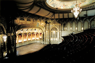
    Opened in 1927 as a movie theatre palace and vaudeville house, Vancouver’s Orpheum Theatre was for many years Canada's largest and most opulent theatre. A much-loved concert space and architectural gem, the 2,688-seat venue located at 884 Granville Street was revitalized in the mid-1970s and recognized as a National Historic Site in 1979. Operated by Vancouver Civic Theatres, it remains one of Canada's premier concert halls and presents a wide variety of classical and contemporary performances. It is the permanent home of the Vancouver Symphony Orchestra (VSO) and has been the main venue for the Vancouver Bach Choir, the Vancouver Cantata Singers, the Vancouver Chamber Choir and the Vancouver Recital Society.

    "https://d3d0lqu00lnqvz.cloudfront.net/media/media/025832f7-751c-4383-b71e-301b8ad133d8.jpg" // resources/views/front/categories/view.blade.php
    
    https://d3d0lqu00lnqvz.cloudfront.net/media/media/025832f7-751c-4383-b71e-301b8ad133d8.jpg Orpheum Theatre (Vancouver)
  • Article

    Orpheum Theatre

    Designed by architect Benjamin Marcus Priteca in "conservative Spanish Renaissance" style and financed by Vancouver businessman Joseph Langer, the Orpheum Theatre was for many years Canada's largest and most opulent theatre.

    "https://d3d0lqu00lnqvz.cloudfront.net/media/media/025832f7-751c-4383-b71e-301b8ad133d8.jpg" // resources/views/front/categories/view.blade.php
    
    https://d3d0lqu00lnqvz.cloudfront.net/media/media/025832f7-751c-4383-b71e-301b8ad133d8.jpg Orpheum Theatre
  • Article

    Orpheum Theatre (Montréal)

    The Orpheum Theatre/Théâtre Orpheum was an 1,100-seat auditorium located at 525 Sainte-Catharine Street West in Montréal.

    "https://www.thecanadianencyclopedia.ca/images/tce_placeholder.jpg?v=e9dca980c9bdb3aa11e832e7ea94f5d9" // resources/views/front/categories/view.blade.php
    
    https://www.thecanadianencyclopedia.ca/images/tce_placeholder.jpg?v=e9dca980c9bdb3aa11e832e7ea94f5d9 Orpheum Theatre (Montréal)
  • Article

    Oshawa

    Oshawa, ON, incorporated as a city in 1924, population 159,458 (2016 census), 149,607 (2011 census). The city of Oshawa is located 52 km east of Toronto on Lake Ontario. Originally called Skae's Corners, its present name is an Ojibwa term meaning “that point at the crossing of the stream where the canoe was exchanged for the trail.” In 1974, Oshawa became part of the newly formed Regional Municipality of Durham.

    "https://www.thecanadianencyclopedia.ca/images/tce_placeholder.jpg?v=e9dca980c9bdb3aa11e832e7ea94f5d9" // resources/views/front/categories/view.blade.php
    
    https://www.thecanadianencyclopedia.ca/images/tce_placeholder.jpg?v=e9dca980c9bdb3aa11e832e7ea94f5d9 Oshawa
  • Article

    Music in Oshawa

    City incorporated in 1924 and located on Lake Ontario, 53 km east of Toronto. In 1778 the first settlers in the area, United Empire Loyalists, were given Crown land. In 1850 the community was declared a village, and the name Oshawa was adopted.

    "https://www.thecanadianencyclopedia.ca/images/tce_placeholder.jpg?v=e9dca980c9bdb3aa11e832e7ea94f5d9" // resources/views/front/categories/view.blade.php
    
    https://www.thecanadianencyclopedia.ca/images/tce_placeholder.jpg?v=e9dca980c9bdb3aa11e832e7ea94f5d9 Music in Oshawa
  • Article

    Osoyoos

    Osoyoos, BC, incorporated as a town in 1946, population 4845 (2011c), 4752 (2006c). The Town of Osoyoos is located on Osoyoos Lake, 60 km south of Penticton in the OKANAGAN VALLEY.

    "https://www.thecanadianencyclopedia.ca/images/tce_placeholder.jpg?v=e9dca980c9bdb3aa11e832e7ea94f5d9" // resources/views/front/categories/view.blade.php
    
    https://www.thecanadianencyclopedia.ca/images/tce_placeholder.jpg?v=e9dca980c9bdb3aa11e832e7ea94f5d9 Osoyoos